What Makes a Place Rural?
What Makes a Place Rural?
The 2016 electoral map, with its seas of rural red, has served as the basis for a misleading and simplified shorthand for urban and rural life. These maps suggest different approaches.
Since “rural” is, at its most basic, a geographic distinction, it seems as though whatever other difficulties we might have pinpointing the essence of rural America, we should at least have a relatively easy time placing it on the map. Yet if we begin looking for a convenient cartographic borderline where the city ends and rural life begins, we find not only that these categories evade convenient definitions, but also that the ways Americans orient themselves in terms of politics and culture have a complicated and by no means deterministic relationship with how they orient themselves in terms of geography.
The practical-minded demographers of the Census Bureau, for instance, can’t settle on a single answer about where exactly to find rural America. The prevailing bureaucratic definition is a negative one: certain parts of the country are determined to be urban, and the leftover is rural. One complicated Census flowchart explains the many considerations that go into defining an urban area; at the end of the flowchart, “everything not urban” points to a vestigial “rural” category. Other attempts to demarcate the boundaries of rural America draw on functional characteristics like distance from market centers or economic dependence on primary production. The Department of Agriculture offers researchers the oracular advice that one should choose the definition of rurality that “best fits the needs of a specific activity” from over two dozen such categorization methods in use by the federal government alone.
Even taken together, density, population, land use, morphology, economic structure, and demographic composition leave an unsatisfactory final conclusion about rurality’s whereabouts. Is Central Park rural? (It has a near-zero residential population density, and its primary economic function is outdoor recreation and agriculture.) What about the oil patches of North Dakota? (They are intensely industrialized, draw on a diversified labor pool, and feature many laborers living close together in quick-build housing.)
Many people now think of a kind of political geography, a red-and-blue map of America, as offering a shorthand for the practical ramifications of the urban–rural distinction. But this also breaks down on even a casual examination. Vermont, by some definitions one of the most rural states in the country, is also one of the bluest, not to mention the home base of the Democratic presidential primary’s self-styled democratic socialist candidate. Meanwhile, the strongest results for Donald Trump in New York’s Republican primary came from the New York City borough of Staten Island, where the future president—himself a resident of the nation’s largest city—earned a margin of victory more than double that returned by most of the state’s rural counties. More voters pulled the lever for Trump in fully urbanized Harris County, the home of Houston, than in all of North and South Dakota combined.
Some interesting attempts at slicing the statistics have suggested more complicated portraits of rurality. Lara Putnam and Gabriel Perez-Putnam, writing in Washington Monthly, show that the presence of dollar stores is a useful indicator of which congressional districts flipped toward Trump in 2016 and then back toward Democrats in the 2018 midterms. The political scientist Jonathan Rodden has analyzed precinct-level voting results to show that there is a “a fascinating fractal-like relationship between population density . . . and Democratic voting” in both major metropolitan areas and small town centers alike; the same pattern is the subject of a new research brief on the “density divide” prepared by Will Wilkinson for the libertarian Niskanen Center.
What follows are four attempts to visualize the geography of rural America along different lines. If the 2016 electoral map, with its seas of rural red, has served not only as emotional succor for Donald Trump but also as the basis for a misleading and simplified shorthand for urban and rural life, these maps suggest different approaches. They blur the edges between these categories or redraw them along different lines that work against the racially homogenizing or ideologically rigid essentialization of one particular type of “authentic” rurality. And they invite us to think more carefully about how the where of culture and politics actually works: not just filling voting results or demographic statistics into empty geographic containers, but emphasizing the conduits of power, the environmental forces, and the historical patterns of community structure that connect people to places.
City in a Garden
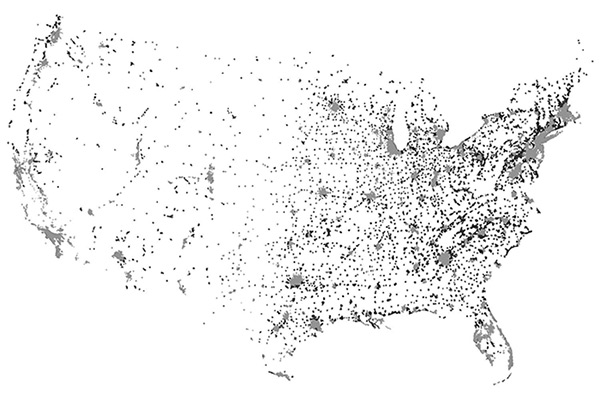
The Census’s “urban area” classification encompasses almost everywhere that people live near to one another, including places that hardly evoke city life, like Newberry, Michigan, a town of 1,519 in the Upper Peninsula, or Big Lake, Texas, a high plains crossroads of 2,936 souls. And the image of “small town” has always shared conceptual resonance with that of far-flung farmsteads and ranches in the archetype of rurality. This map shows all of the nation’s Census-defined “urban areas,” shaded by the degree of rurality of their enclosing county. The splashes of pale grey on the coasts and in the industrial heartland are the truly urban centers: urban areas in urban counties. The white areas are undoubtedly rural: they lie outside of even the smallest urban blips. But the darker gray and black flecks that dot the rest of the country are a different kind of geography: “urban” centers in predominantly rural places, including some of the landscapes documented in this issue—Forrest City, Arkansas; Whiteville, North Carolina; and Fergus Falls, Minnesota. In places like these, people may identify with certain aspects of rural life but nevertheless find themselves in proximity to the rudiments of an urban welfare state: a community college, a food shelf, perhaps even subsidized housing.
The Geography of Disinvestment
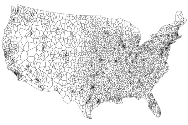
One way to redefine rurality is by its distance from the centers of capital accumulation and its relationship to spatially differentiated disinvestment. In keeping with that definition, this map portrays rurality as a social injustice that deserves recompense. Territory is divided according to the nearest hospital; each cell has one hospital at its geographic center, showing just how far rural patients may need to travel in places like the mountain West or even northern New England in order to receive medical care. Meanwhile, rural hospitals are being shuttered at an accelerating rate, and services that are less lucrative for the profit-seeking healthcare industry, like maternity wards, have been disappearing even faster. Expectant mothers in many parts of the country now have to make contingency plans in case their child is born during what might be a several-hour drive to the nearest birthing center. If anything, this map understates the distance of some rural communities from public services like hospitals, since it treats distances as the crow flies and makes no adjustment for the crumbling roads, mountainous terrain, and lack of public transportation that are found in many rural places.
Hints of Rural Egalitarianism
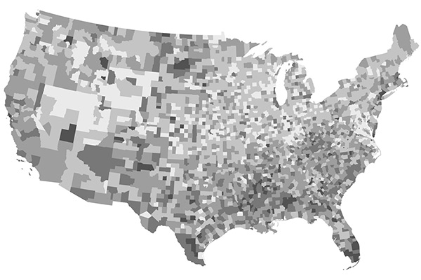
In 1912, the rural progressive journalist William Allen White boasted that Marion County, Kansas, had the highest per capita bank deposits of any county in the nation and yet not a single millionaire, while its jail and poorhouse were barely occupied. Indeed, rural America has, at certain moments and under certain conditions, featured some of the most economically egalitarian communities in the history of the United States. This map shows the Gini coefficient, a measure of inequality, across U.S. counties, averaged from 2009 to 2014. Light-shaded counties are relatively equal while dark-shaded counties have more inequality. In contrast to the familiar red-and-blue map of two Americas, here we see that the liberal coastal cities have some of the most unequal and unfair economies, while a swath of relative equality cuts through a patchwork of rural America. The divide here doesn’t match conveniently onto an urban–rural binary: rural counties in the South, as well as Indian reservations, also have staggering levels of inequality. And some suburban counties score well specifically because they have managed to rig their residential geographies to keep the poor out. Still, a map like this suggests that there are features of some rural societies that might serve as models, rather than hated counterexamples, for the left.
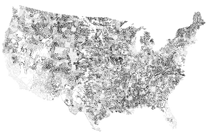
Toward a Regional United States

For a brief moment around the 1930s, a strand of left-wing thought proposed healing the divisions between city and countryside while fighting against the homogenizing centralization of capitalist development by appealing to a “regional” geography of cultural identity, resource conservation, and economic planning. One of the templates for this regionalism was environmental. Recognizing that the patterns of the natural world rarely matched well with the arbitrary divisions drawn up for political units, these regionalists hoped that lessons from ecology, then still a nascent discipline, could reorient our ways of thinking about common problems. This map shows the rivers and streams of the United States—which have been flowing in more or less the same pattern since long before the human division of the landscape into rural and urban kingdoms. Their paths are shaded according to the county classifications they run through: pale gray is a rivercourse running through an urban county, while the darker colors run through more rural counties. As the rivers cut and wind their way from place to place, changing from rural to urban and back along their path to the sea, they should serve as a reminder that there are many problems—from water pollution to the concentration of carbon dioxide in the atmosphere—that confront us as a stitched-together unit regardless of where we live, city or suburb or countryside.
Garrett Dash Nelson is a historical geographer based in Boston. He is a former fellow at the Society of Fellows at Dartmouth College.